


A sudden release of water from Bhutan’s Sintaphu Lake has raised concerns over rising water levels in downstream rivers. Authorities in Assam and West Bengal have activated precautionary measures, while the NDRF says there is no immediate cause for concern.
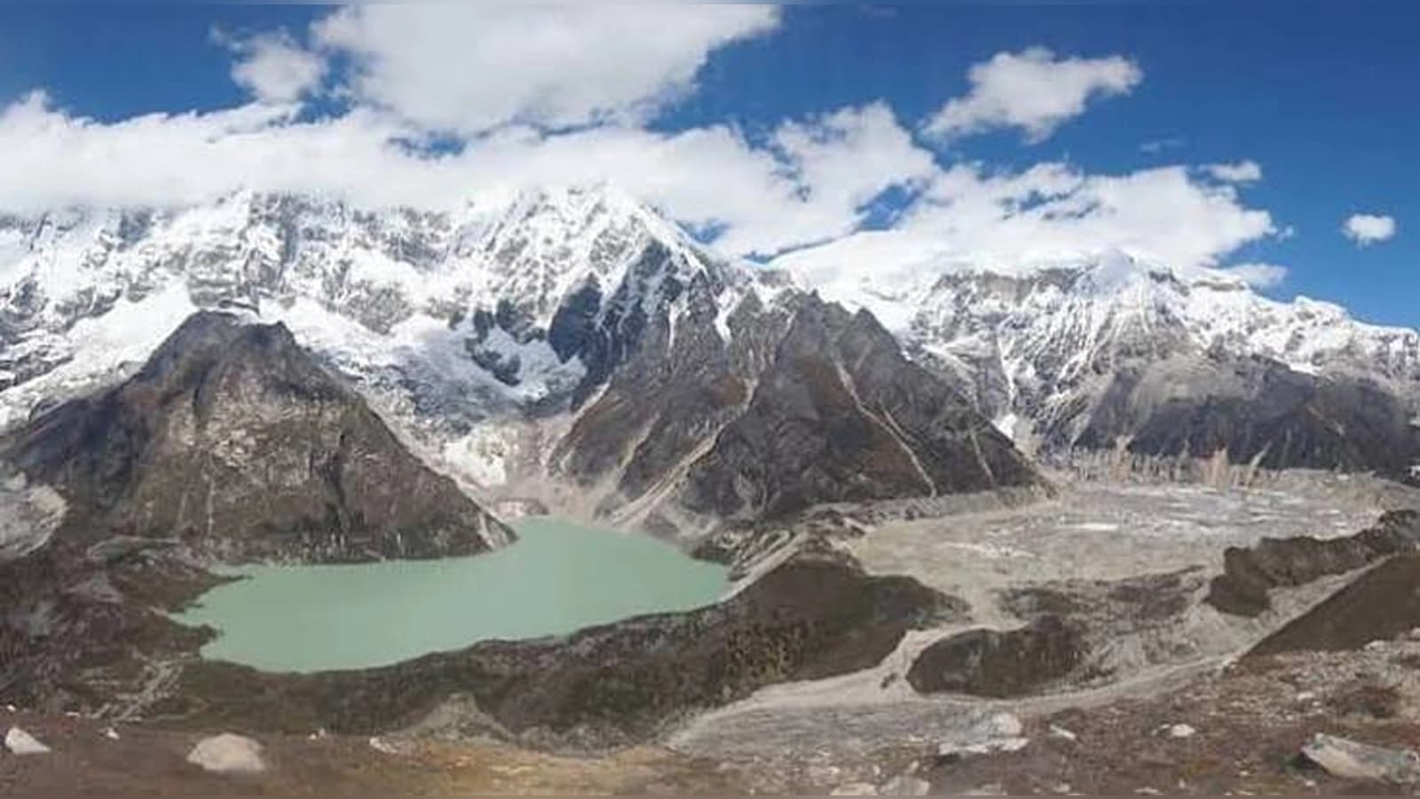
Bhutan Glacial Lake
A glacial lake outburst flood (GLOF) in Bhutan has prompted flood warnings across parts of Assam and North Bengal, putting authorities in the two Indian states on alert. The incident, reported on October 29, has raised concerns about a possible sudden rise in the water level of the Sankosh River, which flows from Bhutan into India.
According to media reports, the outburst occurred at Sintaphu Lake, also known as Sintaphu Lake, in Bhutan’s Gasa district. Approximately 7.4 million cubic meters of water, equivalent to 74 lakh cubic meters, was reportedly released from the lake, triggering flash floods in the surrounding areas.

The incident damaged infrastructure in Bhutan, including the Gasa Tshachu hot spring complex, sections of the Punakha-Gasa highway and roads connecting the remote Laya region. A solar-powered irrigation system in the Punakha area was also reportedly affected. No deaths or injuries had been reported in Bhutan as of the morning of October 30.
Why Are Assam and North Bengal on High Alert?
The primary concern for Indian authorities is the possibility of floodwater travelling downstream through Bhutan’s river network and entering India. Following information received from the Indian Embassy in Bhutan, the Central Water Commission (CWC) issued a special flood advisory on October 29. It warned that the sudden release of water could increase water levels in the Sankosh River, particularly affecting vulnerable areas in Alipurduar district of West Bengal and Dhubri district of Assam.
According to reports citing the advisory, floodwater was initially expected to reach the India-Bhutan border within approximately six to eight hours. The estimate prompted authorities to monitor river conditions and prepare for a possible rise in water levels.
The river system explains the cross-border concern. Water released from Sintaphu Lake flows into the Mo Chhu River, which meets the Pho Chhu at Punakha to form the Punatsangchhu. As the river enters India, it is known as the Sankosh and eventually connects with the Brahmaputra river system.
More Than 10,000 People Moved to Safer Locations in Alipurduar
West Bengal's Alipurduar district has emerged as one of the main areas of concern. The administration initiated precautionary evacuations in vulnerable riverbank settlements to reduce the risk to residents in case of a sudden rise in water levels. According to a report more than 10,000 people had been moved to safer locations. Around 4,000 to 5,000 people were reportedly staying in relief shelters, while approximately 6,000 others had moved to safer places. Schools and community buildings were being used to accommodate people.
Cooch Behar district has also been placed under alert, particularly in areas near the Sankosh and Raidak rivers. Authorities have advised residents in vulnerable locations, including parts of Kumargram and Tufanganj-II, to remain cautious.
The situation in Assam is different. Dhubri and Kokrajhar are among the districts being closely monitored. Chief Minister Himanta Biswa Sarma said the state government was keeping a watch on vulnerable areas and coordinating with disaster response agencies. However, reports citing the Assam State Disaster Management Authority (ASDMA) indicated that large-scale evacuations had not been initiated in Dhubri or other Lower Assam districts at that stage. River levels were reported to be stable.
NDRF Says No Immediate Cause for Concern
The National Disaster Response Force (NDRF) has been placed on alert as a precautionary measure. On October 30, NDRF Director General Piyush Anand said there was no immediate cause for concern based on the information available at the time. He said the force was coordinating with the Central Water Commission, India Meteorological Department and other agencies to monitor the situation and remain prepared for any emergency.
In Assam, Chief Minister Himanta Biswa Sarma said disaster response teams were in contact with the NDRF and other agencies. He urged residents in vulnerable areas to follow official advisories and cooperate with the administration. West Bengal authorities have also issued precautionary instructions and continued monitoring river conditions. Tourism Minister Sankar Ghosh said the administration was on alert and that no major incident had been reported in Alipurduar at the time of his remarks.
What Is a Glacial Lake Outburst Flood?
A Glacial Lake Outburst Flood, commonly known as a GLOF, occurs when a large volume of water stored in a glacial lake is suddenly released. Such lakes are generally formed by melting glaciers and may be held back by natural barriers made of rocks, soil, ice and glacial debris. When these barriers weaken or collapse, water can escape rapidly and flow towards lower-altitude areas. Along the way, the floodwater can carry rocks, mud, boulders and other debris, increasing its destructive potential.
Heavy rainfall, landslides, avalanches, earthquakes and changes in glacial conditions can contribute to the instability of glacial lakes. However, the precise trigger behind the Sintaphu Lake outburst has not been established in the reports available so far. Therefore, the incident should not be attributed directly to climate change without a scientific assessment.
Bhutan's Vulnerability to Glacial Floods
Located in the eastern Himalayas, Bhutan has numerous glaciers and glacial lakes, some of which pose risks to communities and infrastructure downstream. Reports identify Sintaphu as one of Bhutan's 17 potentially dangerous glacial lakes. The lake is situated in the upper reaches of the Mo Chhu river system, connecting it to waterways that eventually flow into India.
Bhutanese specialists reportedly conducted studies of the lake between May and June 2023, examining its surrounding terrain, natural barriers and the glacier feeding it. Monitoring measures were also introduced to improve surveillance. The latest incident has renewed attention on the risks associated with glacial lakes in the Himalayan region and the need for effective monitoring systems.
Agencies Monitoring River Levels in Both Countries
Authorities in Bhutan and India have stepped up monitoring following the outburst. The Central Water Commission is tracking river conditions at monitoring stations, including Barobisha, Sankosh LRP, Golakganj and Baladoba.
In Bhutan, warning sirens were reportedly activated along the Mo Chhu and downstream sections of the Punatsangchhu. The Punatsangchhu-II hydropower plant also reportedly suspended power generation and opened its spillway gates to help manage floodwater and debris. Indian agencies, including the CWC, NDRF and state disaster management authorities, are coordinating their response to monitor the situation and prepare for possible emergencies.

Apple promotes Indian-origin engineer Rajesh Ambati to vice-president of engineering
Bhutan Glacial Lake Outburst Triggers Flood Alert in Assam and North Bengal; Over 10,000 Evacuated

West Bengal to bar school teachers, non-teaching staff from political activities; considers performance-based increments

Schools closed in Chhattisgarh, Odisha amid heavy rainfall; check district-wise holiday updates

UP schools closed in 60 districts for UPSSSC PET 2026; Noida, Ghaziabad among affected areas

IIT Kharagpur to Establish India’s First Physical AI School with ₹35 Crore Investment

Japan wants more foreign workers, but who will teach them Japanese?

Patrick Stewart Dies at 86: Star Trek's Captain Picard and X-Men's Professor X Remembered

UAE makes schoolchildren priority for free flu vaccines across emirates

NTU Singapore, VFT launch joint research lab to develop safer batteries for renewable energy storage

Apple promotes Indian-origin engineer Rajesh Ambati to vice-president of engineering
Bhutan Glacial Lake Outburst Triggers Flood Alert in Assam and North Bengal; Over 10,000 Evacuated
West Bengal to bar school teachers, non-teaching staff from political activities; considers performance-based increments
Schools closed in Chhattisgarh, Odisha amid heavy rainfall; check district-wise holiday updates
UP schools closed in 60 districts for UPSSSC PET 2026; Noida, Ghaziabad among affected areas
IIT Kharagpur to Establish India’s First Physical AI School with ₹35 Crore Investment
Japan wants more foreign workers, but who will teach them Japanese?
Patrick Stewart Dies at 86: Star Trek's Captain Picard and X-Men's Professor X Remembered
UAE makes schoolchildren priority for free flu vaccines across emirates
NTU Singapore, VFT launch joint research lab to develop safer batteries for renewable energy storage
Copyright© educationpost.in 2026 All Rights Reserved.