

The UN General Assembly has backed the Equal Earth projection to present the relative size of countries and continents more accurately, challenging distortions in the widely used Mercator map and sparking a debate over how the world is visually represented.
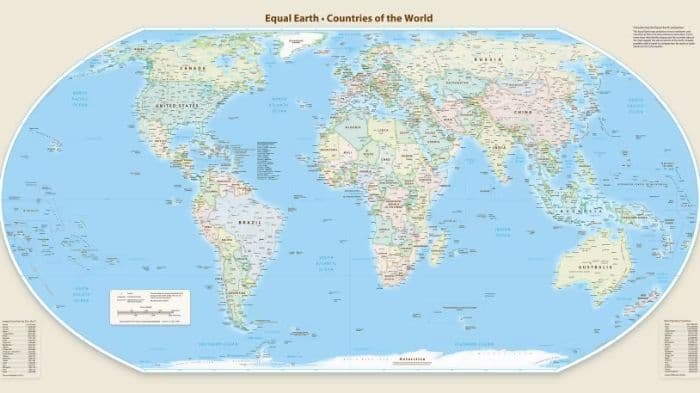
Look at a conventional world map and Greenland can appear almost as large as Africa. Europe can also appear larger than South America. But these visual differences do not reflect the actual size of the continents. They are the result of how the three-dimensional Earth is projected onto a flat map.
That familiar representation is now facing a challenge at the United Nations, where the General Assembly has backed a resolution encouraging the use of the Equal Earth Projection and other equal-area map projections to represent the relative size of continents more accurately.

The resolution, backed by India, was adopted with 164 votes in favour, one against and six abstentions. The United States was the only country to vote against it, while Estonia, Georgia, Lithuania, Moldova, Serbia and Ukraine abstained. The measure is advisory and does not require countries or institutions to abandon the Mercator projection.
Why the Mercator map makes some places look bigger
The Mercator Projection was developed by Flemish cartographer Gerardus Mercator in the 16th century and was created for marine navigation. It preserves directions in a way that made it useful to sailors, but this comes at the expense of accurately representing the area of land masses.
The distortion becomes more pronounced towards the poles. Greenland, for example, can appear comparable in size to Africa on a Mercator map, even though Africa is about 14 times larger. Europe can also appear larger relative to South America, although South America has about 75 per cent more land area.
The Equal Earth Projection, developed in 2018, takes a different approach. It is an equal-area projection, meaning that it is designed to preserve the relative areas of continents and countries more accurately.
The UN resolution describes it as a relevant option for improving the accuracy of global cartographic representation and encourages its use along with other equal-area projection methods.
The change is particularly visible for regions farther from the Equator. The United States and Russia appear smaller on an Equal Earth map than they do on the Mercator projection, while Africa appears considerably larger relative to them.
India's representation changes comparatively little. The most noticeable difference is that the Indian peninsula appears slightly less angular and marginally wider on the Equal Earth projection.
Why the map debate has become a Global South issue
The resolution was led by Togo and focused particularly on the representation of Africa and other regions of the Global South. Togo's Foreign Minister Robert Dussey argued that correcting the map was about representing different regions more accurately and with dignity.
The UN resolution itself states that historical distortions in the representation of continental sizes have cognitive, educational, cultural, geopolitical and socioeconomic effects. It calls for greater accuracy in printed and digital mapping tools.
The debate has also exposed political differences over how the issue should be viewed. A US representative at the UN criticised the resolution as part of what she described as a broader “radical ideological project” and questioned its relevance to the organisation's work.
Togo, meanwhile, stressed that the initiative was not directed against any particular country or cartographic tradition. Dussey said the objective was to improve how the world is represented rather than to change the geography itself.
Russia, whose landmass also appears substantially smaller on the Equal Earth projection than on Mercator, supported the resolution and described it as anti-colonial. The European Union also supported it, while stressing that the measure was limited to cartographic representation for educational, awareness-raising and geographical-literacy purposes.
France also announced a change in its approach to world maps. French Foreign Minister Jean-Noël Barrot said the country would move away from Mercator in favour of representations more faithful to actual surface areas, tailored to specific uses.
The debate has gained added political attention in the United States, where President Donald Trump has spoken about expanding US territory, including through remarks concerning Canada and Greenland. The Equal Earth projection, however, is fundamentally a cartographic issue: it does not alter national borders or the physical size of any country.
The UN resolution also does not declare the Mercator projection invalid. Its original purpose was navigation, and the projection remains useful for that purpose. Instead, the resolution encourages the use of equal-area projections where accurately showing the relative size of continents and countries is important.
The larger point behind the debate is straightforward: every flat map of a spherical Earth involves some form of distortion. Different projections prioritise different qualities, including area, shape, distance or direction. The Equal Earth projection prioritises relative area, offering a visual representation in which the size of Africa and other equatorial regions is closer to their actual proportions.
The resolution does not require countries or institutions to abandon the Mercator projection, but it encourages wider use of equal-area maps where accurate representation of relative size matters.
.jpg&w=256&q=75)
From Class 8 to hospital owner: Rajasthan Police expose alleged fake doctor registration

ENTOD Pharmaceuticals Partners with DPGU and BNCP to Advance Pharmaceutical Research
IIT Kanpur Concludes Samanvay 2026, Announces Gates Foundation Partnership on Affordable Diagnostics

Who will lead Keralam's universities? Government begins steps to appoint permanent VCs
OILF, Rangeet Expand SEEK Curriculum to 180 Schools Across Mumbai
From Class 8 to hospital owner: Rajasthan Police expose alleged fake doctor registration
Who will lead Keralam's universities? Government begins steps to appoint permanent VCs
%20(1)%20(1).jpeg&w=256&q=75)
Why does cracking JEE Advanced depend on coaching? IIT Kanpur Director calls for a revamp
.jpg&w=256&q=75)
NEET-PG 2026 answer key row: Supreme Court seeks NBEMS response on missing question papers
.png&w=256&q=75)
42 Iraqi universities feature in QS Arab Region University Rankings 2027

From Class 8 to hospital owner: Rajasthan Police expose alleged fake doctor registration
ENTOD Pharmaceuticals Partners with DPGU and BNCP to Advance Pharmaceutical Research
IIT Kanpur Concludes Samanvay 2026, Announces Gates Foundation Partnership on Affordable Diagnostics
Who will lead Keralam's universities? Government begins steps to appoint permanent VCs
OILF, Rangeet Expand SEEK Curriculum to 180 Schools Across Mumbai
From Class 8 to hospital owner: Rajasthan Police expose alleged fake doctor registration
Who will lead Keralam's universities? Government begins steps to appoint permanent VCs
Why does cracking JEE Advanced depend on coaching? IIT Kanpur Director calls for a revamp
NEET-PG 2026 answer key row: Supreme Court seeks NBEMS response on missing question papers
42 Iraqi universities feature in QS Arab Region University Rankings 2027
Copyright© educationpost.in 2026 All Rights Reserved.