


Researchers analysed decades of river-flow records and satellite images to examine how the Ranjit Sagar reservoir, sand mining and human activity have reshaped the Ravi River’s downstream floodplain.
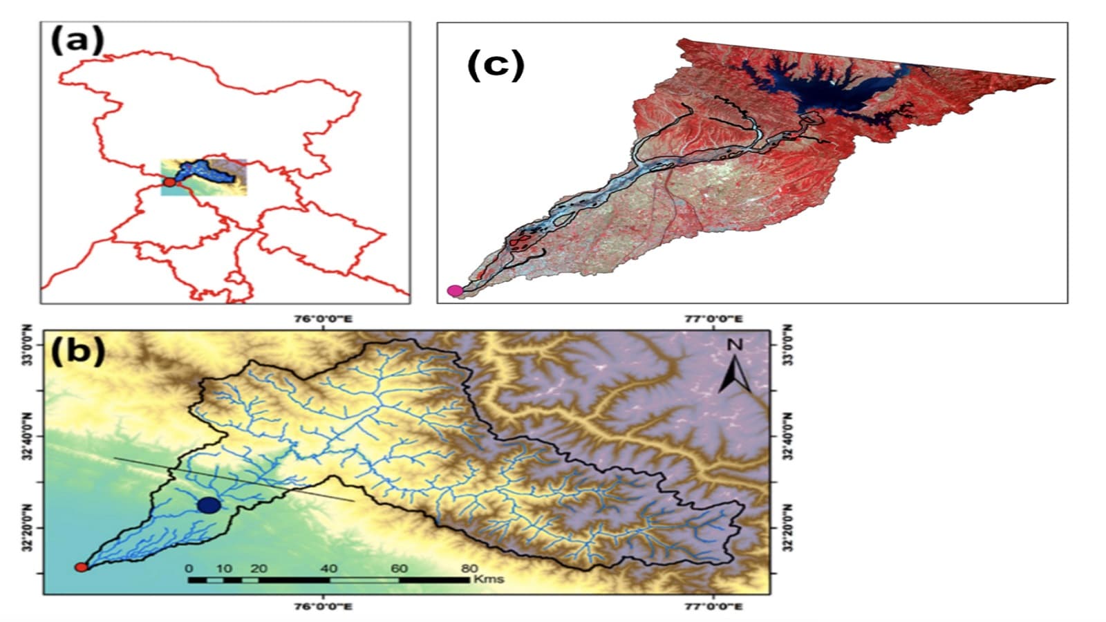
The surface-water area across a section of the Ravi River’s downstream floodplain has declined by around 80%, or fivefold, following the start of operations at the Ranjit Sagar reservoir, according to a study involving researchers from the Indian Institute of Technology Gandhinagar (IITGN).
Published in the journal Next Sustainability on August 28, 2026, the research examines changes in river discharge, surface water, vegetation and human activity. The findings suggest that reservoir regulation and sand mining, alongside other human interventions, have contributed to changes in the river’s channel and surrounding floodplain.

The study, titled “Unraveling the impacts of reservoir regulation and sand mining on the Ravi River, India,” combines long-term discharge information with satellite-based observations to investigate how the river landscape has evolved over several decades.
The researchers estimated that the mean surface-water area declined from 17.35 square kilometres before the reservoir began operating to 3.46 square kilometres in the subsequent period. This represents an approximately 80% reduction, meaning the measured surface-water area became about five times smaller.
The paper’s abstract also reports a 36% decline in dry-season river discharge following the reservoir’s construction. These findings concern different measures: one describes the area covered by surface water, while the other relates to the flow of water through the river.
The distinction is important because a reduction in visible water-covered area does not, by itself, establish an equivalent decline in the total water resources available across the entire Ravi River basin.
The Ranjit Sagar Dam, also known as the Thein Dam, was constructed on the Ravi River and began operating in 2001. Reservoirs provide important services, including water storage, irrigation support and hydropower generation, but their operation can also alter the timing and magnitude of downstream river flows.
Natural rivers experience seasonal fluctuations that influence sediment transport, channel movement and the frequency with which water spreads across adjoining floodplains. When these patterns change, the landscape can gradually respond.
For the Ravi River study, the researchers examined daily discharge data spanning 1980 to 2019 and compared conditions before and after reservoir operations began. The research also assessed pre-monsoon conditions during April and May to examine changes in the river’s flow regime.
The university’s press release reports that median discharge decreased from 296 cubic metres per second during 1980–2000 to 221 cubic metres per second during 2001–2019. These figures represent a reduction of approximately 25.3%. The paper’s abstract separately reports a 36% decline in dry-season discharge, a figure that should not be confused with the press release’s median-discharge comparison.
Satellite imagery provided another important source of evidence. Images from 1992 and 1998 showed a more extensive network of surface water across the floodplain. Later observations from 2003, 2009 and 2019 indicated that several of these water features had become less prominent.
The researchers also observed increased vegetation in areas where the active water-covered region had contracted.
Floodplains are dynamic environments shaped by the movement of water and sediment. Periodic flooding can create and maintain habitats, redistribute sediment and sustain connections between the main river channel and surrounding land.
When these processes become less frequent, vegetation may establish itself more easily in areas that were previously inundated. Over time, this can contribute to changes in floodplain structure and connectivity.
The findings indicate a shift in the relationship between the river channel and its surrounding landscape. However, the study’s reported observations should not be interpreted as direct measurements of changes in agricultural output or the economic losses experienced by local communities.
The study also investigated the influence of sand extraction and other human activities on the river and its floodplain.
Using high-resolution imagery, including Google Earth observations, the researchers identified features such as artificial pits, altered channel pathways and other changes associated with human intervention. The effects varied across different parts of the floodplain rather than occurring uniformly throughout the study area.
Sand mining can alter riverbed levels and sediment movement, potentially affecting channel stability and the surrounding landscape. When combined with changes in water flow, these pressures may intensify river-channel and floodplain modifications.
The researchers therefore emphasise the importance of examining reservoir regulation, sediment movement and land-use changes together rather than treating them as independent issues.
The findings identify possible environmental and water-management concerns, but they do not establish that every observed landscape change was caused exclusively by the reservoir. Sand mining, local human activity and other environmental influences also need to be considered.
Sediment is a natural component of river systems. Rivers transport sand and other material downstream, helping shape their channels and maintain floodplain processes.
Dams and reservoirs can retain sediment that would otherwise travel downstream. Changes in sediment supply, combined with altered water flows, can affect channel erosion, deposition and river morphology.
India’s Central Water Commission has published guidelines addressing longitudinal connectivity through dams, including the movement of sediment and fish. The guidance discusses reservoir sediment-management approaches that can help reduce the downstream effects of sediment trapping.
The Ravi River findings reinforce the need to consider these processes when planning and operating water infrastructure, particularly where river ecosystems and human uses depend on seasonal water movement.
The study adds to wider research on the environmental effects of dams, sediment extraction and changes in land use. Similar pressures have been examined in river systems around the world, where water infrastructure and human activity can alter the relationship between rivers and their floodplains.
For India, the findings highlight several considerations for long-term water planning:
Monitor river flows: Regular assessment of seasonal discharge can help identify changes in downstream water conditions.
Track floodplain changes: Satellite imagery can help authorities monitor surface-water extent, vegetation and changes in river channels.
Improve sediment management: Reservoir operations should consider downstream sediment transport and river connectivity.
Regulate sand extraction: Monitoring mining activity can help identify areas where river channels and floodplains are undergoing substantial changes.
Integrate ecological considerations: Water planning should consider river ecosystems alongside irrigation, hydropower and other human requirements.
The research is consistent with the broader objectives of India’s National Water Mission, which include water conservation, reducing wastage and promoting integrated water-resource management. It also relates to the United Nations Sustainable Development Goal 6, which calls for sustainable water management and the protection and restoration of water-related ecosystems.
The study does not provide a complete assessment of the Ravi River basin’s total water balance or quantify the precise contribution of each factor to the observed changes. Further monitoring and research would help clarify how reservoir operations, sediment extraction, climate variability and local land-use changes interact over time.
Nevertheless, its findings underline an important point for policymakers: sustainable reservoir management requires attention not only to the quantity of water stored and released, but also to the river processes that maintain downstream channels, floodplains and ecosystems.
Ravi River’s Surface-Water Area Shrinks Fivefold After Reservoir Operations, IIT Gandhinagar Study Finds

AI can support learning, but the thinking, curiosity and final effort must belong to the student
SRM University-AP: 20 Faculty Members Named Among World’s Top 2% Scientists

NMC clarifies digital authentication of medical records: Key rules on liability, security and foreign experts
NMC patient safety directive explained: Medical colleges must appoint nodal officers, form committees
NMC clarifies digital authentication of medical records: Key rules on liability, security and foreign experts

‘Dear Italy, how much do you cost us?’ Students pitch tents over soaring rents

Australia passes bill to expand university access and support disadvantaged students

HBKU’s PlasmaPure advances to semifinals in global water desalination competition
Karnataka student elections return after 37 years: Why political restrictions and university polls remain contentious

Ravi River’s Surface-Water Area Shrinks Fivefold After Reservoir Operations, IIT Gandhinagar Study Finds
AI can support learning, but the thinking, curiosity and final effort must belong to the student
SRM University-AP: 20 Faculty Members Named Among World’s Top 2% Scientists
NMC clarifies digital authentication of medical records: Key rules on liability, security and foreign experts
NMC patient safety directive explained: Medical colleges must appoint nodal officers, form committees
NMC clarifies digital authentication of medical records: Key rules on liability, security and foreign experts
‘Dear Italy, how much do you cost us?’ Students pitch tents over soaring rents
Australia passes bill to expand university access and support disadvantaged students
HBKU’s PlasmaPure advances to semifinals in global water desalination competition
Karnataka student elections return after 37 years: Why political restrictions and university polls remain contentious
Copyright© educationpost.in 2026 All Rights Reserved.